Understanding Nantucket's Moors
The word "moors" conjures images of Wuthering Heights and windswept British uplands. Nantucket's moors share that aesthetic but have their own unique character, shaped by the island's glacial history, maritime climate, and centuries of human use. Understanding what you're looking at enriches every walk through this landscape.
The moors exist because of sheep. When English settlers arrived in the 1600s, they brought sheep that grazed the interior for nearly three centuries. This grazing prevented forest growth, creating the open heathland that persists today. The vegetation you see - low shrubs of heather, bayberry, and scrub oak rarely more than waist-high - is the legacy of that pastoral history. Without continued management, the moors would eventually revert to forest, so conservation organizations now use controlled burns and selective clearing to maintain this iconic landscape.
Geologically, the moors sit on glacial outwash plains created 15,000 years ago when retreating ice sheets deposited the sand and gravel that forms Nantucket's foundation. The rolling terrain reflects ancient patterns of glacial deposition - the gentle hills are moraines, the depressions are kettle ponds formed when buried ice blocks melted. You're walking on a landscape shaped by forces that operated millennia before humans arrived.
The ecosystem here is surprisingly diverse. Heather blooms purple in late summer. Beach plum produces fruit that locals turn into jelly. Bayberry provides the waxy berries once used for candle-making. Low-bush blueberries offer treats for hikers and birds alike. Scrub oak turns bronze in autumn, while the moors themselves shift from green to gold to russet across the seasons. Wildlife includes white-tailed deer, cottontail rabbits, ring-necked pheasants, and numerous songbirds. Red-tailed hawks and northern harriers patrol overhead, hunting the small mammals that shelter in the dense vegetation.
Polpis Road: The Scenic Route
Polpis Road curves seven miles from downtown Nantucket to Wauwinet, skirting the harbor's northern edge before climbing into the moors and dropping down to the eastern shore. It's consistently rated one of the most beautiful drives in New England, and for cyclists, it represents one of the island's essential rides. But Polpis Road is more than a scenic corridor - it's the access point to Nantucket's finest conservation areas and the gateway to the island's wild interior.
Driving Polpis Road
The drive takes 15-20 minutes without stops, but budget at least an hour if you want to actually experience what makes this route special. Heading east from town, the road passes the Nantucket Golf Club before the landscape opens into rolling moors. Around mile three, you'll reach the turnoff for Altar Rock - don't miss this. Continuing east, the road climbs to its highest point, offering sweeping views across the moors to the harbor. The descent brings you through Quaise, with its mix of historic homes and conservation land, before arriving at Wauwinet, where the road ends and the wilderness begins.
Pull-offs are limited but present. Whenever you see a safe opportunity to stop, take it. The views change constantly as the road winds through the terrain, and photographs from moving vehicles never capture what your eyes actually see.
Biking Polpis Road
Cycling Polpis Road is a Nantucket rite of passage. The route is challenging but manageable for reasonably fit riders, with rolling terrain that includes several significant climbs. Unlike the flat bike paths to Madaket and Sconset, Polpis Road follows the main road with car traffic - there's no dedicated bike lane. However, shoulder width is generally adequate, and most drivers are accustomed to sharing the road with cyclists.
The round trip from downtown to Wauwinet covers about 14 miles. Plan 1.5-2 hours for the cycling itself, plus time for stops. Many cyclists combine the ride with lunch at Topper's at the Wauwinet or a swim at the point before returning. The afternoon light on the return trip is particularly beautiful, illuminating the moors from the west.
A few practical notes: bring water, as there's nowhere to refill between town and Wauwinet. Start early on summer days to avoid the worst heat. The hills are easier in the morning when you're fresh. And if you're not confident riding with traffic, consider driving to a trailhead and walking instead - the conservation areas are just as accessible on foot.
Altar Rock: The Island's High Point
At 101 feet above sea level, Altar Rock barely qualifies as a hill by mainland standards. On Nantucket, it's the summit experience. From this modest elevation, you can see from the south shore to the north shore, from Sankaty Head Light in the east to the outskirts of town in the west. It's the best 360-degree view on the island, and reaching it requires nothing more strenuous than a short walk from the parking area.
The name "Altar Rock" has mysterious origins. Some say it refers to the rock's flat top, suitable for ceremonies. Others suggest Native American spiritual significance. Whatever the etymology, the site has drawn visitors for generations. Today it's managed by the Nantucket Conservation Foundation, whose lands extend across much of the surrounding moorland.
Getting There
The turnoff for Altar Rock Road is on the south side of Polpis Road, approximately three miles from town. The unpaved access road is suitable for most vehicles, though low-clearance sports cars may scrape. The road winds about a mile through conservation land to a small parking area at the base of the hill. From there, it's a five-minute walk up a gentle slope to the summit.
The View
On clear days, the panorama from Altar Rock is astonishing. To the north, Nantucket Harbor sparkles with boats at anchor, while beyond it Coatue's barrier beach curls toward Great Point. East, the moors roll toward Sankaty Head, its lighthouse visible on the bluff. South, the interior moorland stretches to the Atlantic, with Cisco and Madaket beaches glinting in the distance. West, you can pick out downtown's church steeples rising above the tree line.
The best light comes in the two hours before sunset, when the low sun paints the moors in amber and gold. Many photographers time their visits for this magic hour. But the view is worthwhile at any time - early morning brings soft light and often fog lifting from the valleys, while midday offers maximum visibility on clear days.
Trails from Altar Rock
The Altar Rock area serves as a hub for several conservation trails. From the summit, you can walk south into the moors on paths that connect to Sanford Farm's trail network. To the east, trails lead toward the cranberry bogs. These aren't maintained sidewalks - expect sandy paths, occasional mud, and minimal signage. Bring a trail map or use GPS tracking on your phone. The Nantucket Conservation Foundation provides basic maps on their website.
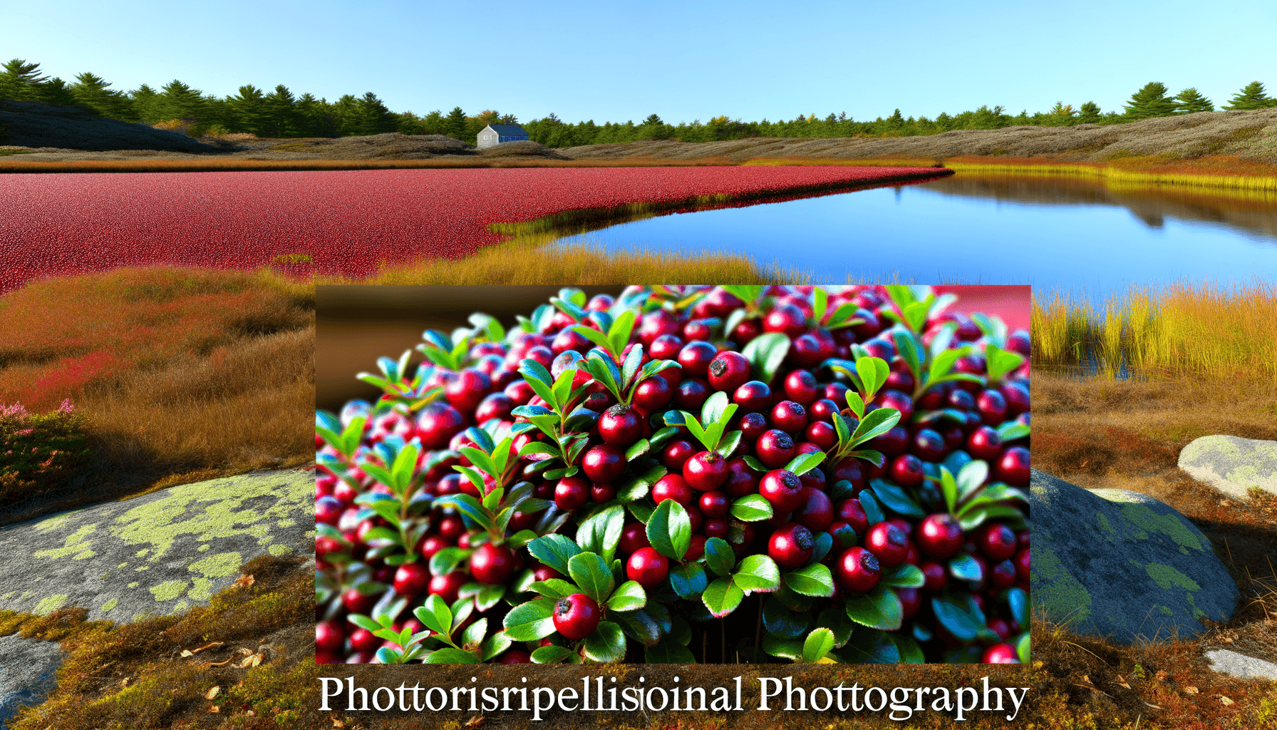
Windswept Cranberry Bog
Nantucket's relationship with cranberries runs deep. The island was once a major producer, with bogs covering hundreds of acres of low-lying land. Today, most commercial production has ceased, but Windswept Cranberry Bog remains active - the largest working cranberry operation on the island and one of the most beautiful spots in any season.
Windswept encompasses about 200 acres of cranberry beds, wetlands, and surrounding upland. The operation is a working farm, but the Conservation Foundation maintains trails around the perimeter that offer intimate views of the bogs without disturbing the agricultural work. It's a remarkable example of conservation and working landscape coexisting.
The Cranberry Cycle
Understanding cranberry cultivation enriches any visit. The berries grow on low, trailing vines in sandy, acidic soils - conditions Nantucket provides naturally. In spring, the vines flower with delicate pink blossoms. Summer brings berry development, the fruit gradually shifting from white to red as it ripens. By October, the bogs blaze crimson, ready for harvest.
The wet harvest, when bogs are flooded and berries float to the surface for collection, creates some of the most photographed scenes on Nantucket. Dates vary depending on weather and ripeness, but early to mid-October usually brings harvest activity. The sight of brilliant red berries floating on dark water, surrounded by autumn-tinted moors, is genuinely unforgettable.
Visiting Windswept
The bog is accessible via a dirt road off Polpis Road, approximately four miles from town. Parking is limited but usually adequate except during peak fall foliage season. A two-mile loop trail circles the main bog complex, with additional paths branching into surrounding conservation land. The terrain is flat and the walking easy - this is one of the most accessible nature experiences on the island.
Best seasons for visiting depend on your interests. Spring brings wildflowers and nesting birds. Summer offers lush green bogs and the chance to see growing cranberries. Fall is the spectacular season, with harvest activity, brilliant colors, and the moors turning gold and russet. Even winter has appeal - the stark landscape, frozen bog surfaces, and possibility of snow create a meditative atmosphere.
Conservation Lands and Hiking Trails
Nearly half of Nantucket is protected conservation land - one of the highest percentages of any community in Massachusetts. The Polpis area contains some of the most significant parcels, offering miles of trails through diverse habitats. These aren't manicured paths with ranger stations and gift shops. They're wild lands maintained by dedicated organizations, offering solitude and natural beauty to anyone willing to explore.
Nantucket Conservation Foundation Properties
The NCF manages more than 9,000 acres across the island, including much of the moorland surrounding Polpis Road. Their properties feature marked trails open to the public, though facilities are minimal. Key areas accessible from Polpis Road include:
- Middle Moors: Rolling heathland with panoramic views, accessible from Altar Rock area. Several miles of interconnected trails.
- Squam Swamp: Unique cedar swamp habitat, one of the few forested areas on the island. Short trail through atmospheric woodland.
- Serengeti: Named for its African-like expanse of open grassland. Prime bird watching territory, especially during migration.
Trustees of Reservations Properties
The Trustees manage Coskata-Coatue Wildlife Refuge at the end of Polpis Road/Wauwinet, one of New England's great barrier beach ecosystems. Access requires either a long walk or participation in a guided tour - the natural history tours are highly recommended for first-time visitors.
Trail Etiquette
These conservation lands depend on responsible use. Stay on marked trails to protect fragile vegetation. No fires, camping, or overnight parking. Dogs are prohibited on most NCF properties - check signage at trailheads. Pack out everything you pack in. During hunting season (October-December), wear orange and be aware that deer hunting is permitted on some parcels.
Bird Watching in the Moors
Nantucket's isolated position, 30 miles off the mainland, makes it a magnet for migrating birds. The moors provide essential habitat for both residents and travelers, and the Polpis area offers some of the island's best birding opportunities. Whether you're a serious lister or simply enjoy watching birds, this landscape delivers.
Resident Species
The moorland supports a characteristic community of breeding birds. Northern harriers nest in the low vegetation, their distinctive flight pattern - tilting and gliding low over the moors - visible throughout the summer. American kestrels and red-tailed hawks hunt the open areas. Ring-necked pheasants, introduced for hunting, have established robust populations. Eastern towhees call from the scrub oak, while yellow warblers nest in the bayberry thickets.
Migration Spectacles
Spring and fall migrations bring waves of birds through the island. The moors serve as resting and feeding habitat for exhausted travelers. Warblers pass through in impressive numbers during May and September. Shorebirds stage around the bog edges. Raptors concentrate at Altar Rock and other high points, riding thermals south in autumn. The open terrain makes spotting easier than in forested areas - binoculars are often all you need.
Best Birding Locations
- Altar Rock: Best for raptors during fall migration. The elevation provides excellent viewing as hawks and harriers work the moors below.
- Windswept Bog edges: Wetland birds, including herons, egrets, and migrating shorebirds. Dawn and dusk most productive.
- Serengeti: Open grassland specialists including meadowlarks and sparrows. Short-eared owls hunt here at dusk during winter.
- Squam Swamp: Forest birds uncommon elsewhere on the island. Listen for woodpeckers and owls.
Resources
The Maria Mitchell Association runs bird walks and maintains local sighting records. Their Natural Science Museum on Vestal Street sells field guides and can provide current information on what's being seen. The Nantucket Biodiversity Initiative also tracks bird populations and welcomes reports from citizen scientists.
Photography in the Moors
The moors are a photographer's paradise - wide open landscapes, dramatic skies, and golden light that seems designed for the camera. Whether you're working with a professional rig or a smartphone, you'll find opportunities at every turn. Here's how to make the most of them.
Best Times for Light
The golden hours - the hour after sunrise and the hour before sunset - transform the moors. Low-angle light illuminates the heath and grasses, creating texture and depth that midday sun flattens. The west-facing slopes catch the best evening light, glowing amber as the sun descends. Altar Rock at sunset is a classic shot for good reason.
Don't discount other conditions. Fog is frequent, especially in early morning, creating atmospheric images where the moors fade into soft gray infinity. Overcast skies provide even light perfect for detail shots and autumn colors. Storm light - those dramatic moments when clouds part and shafts of sunlight strike the landscape - can be extraordinary.
Key Photography Spots
- Altar Rock summit: Panoramic views in every direction. Best at sunset but worthwhile anytime.
- Windswept Bog: Reflections, cranberry colors, wetland textures. Stunning during fall harvest.
- Polpis Road viewpoints: Several pull-offs offer sweeping moor views. Morning light on east-facing slopes.
- Middle Moors trails: Intimate heath landscapes, rolling terrain, wildflowers in season.
Seasonal Highlights
Spring: Wildflowers, fresh green growth, migrating birds. May brings the showiest blooms.
Summer: Heather in bloom turns the moors purple in August. Long golden evenings.
Fall: Peak color season. Cranberry harvest, russet moors, dramatic skies. October is prime time.
Winter: Stark beauty, potential snow, atmospheric fog. Fewer visitors means unobstructed compositions.
Fall Colors in the Moors
Forget Vermont. Nantucket's autumn display may lack the sugar maples, but the moors offer something equally spectacular and far less crowded. From late September through November, the interior transforms into a tapestry of gold, russet, bronze, and crimson that rivals any New England foliage destination.
The colors here are different from mainland fall. Instead of towering trees, you're looking at a horizontal palette spread across rolling terrain. Scrub oak turns bronze and coppery orange. Bayberry shifts to burgundy. The grasses fade from green to gold to silver. And the cranberry bogs blaze the deepest red you'll see anywhere - concentrated color floating on dark water.
The timing varies by year, but the general progression is reliable. Late September brings the first hints of color change. Early October is often peak for the cranberry bogs, coinciding with harvest. Mid to late October brings the moors to full color, with scrub oak leading the display. November fades toward winter, but the russet tones linger long after the last leaves have fallen elsewhere.
For the best fall experience, combine a drive on Polpis Road with stops at Altar Rock and Windswept Bog. Time your visit for late afternoon light when the colors glow most intensely. Bring layers - October mornings can be crisp, and the wind on exposed moors cuts through light clothing.
A Sample Moors Exploration Day
You've got a full day to explore Nantucket's interior. Here's how to make the most of it:
Morning (8 AM - 12 PM)
Start early at Windswept Cranberry Bog when the light is soft and bird activity peaks. Walk the two-mile loop trail, pausing to photograph the bogs and scan for wildlife. The morning quiet allows for closer encounters with deer and birds. Budget 2-3 hours for the full experience with photography stops.
If you're visiting in October, call ahead to check harvest schedules - watching the wet harvest operation is an unforgettable experience.
Midday (12 PM - 2 PM)
Head to Wauwinet for lunch at Topper's, the restaurant at the Wauwinet hotel. The setting alone justifies the trip - views over the harbor toward Great Point. Make reservations in summer season. Alternatively, pack a picnic and find a scenic pull-off along Polpis Road.
After lunch, consider the Coskata-Coatue natural history tour if available, or simply drive back toward town on Polpis Road, stopping at viewpoints you missed in the morning.
Afternoon (2 PM - 5 PM)
Turn off at Altar Rock Road for the main event. Park at the base and walk to the summit for the view. From there, venture into the Middle Moors trails if time permits - even a 30-minute walk into the heath reveals the landscape's character. Return to Altar Rock as afternoon light begins to warm.
Evening (5 PM - Sunset)
Position yourself at Altar Rock summit as the sun descends. The panoramic view becomes increasingly dramatic as shadows lengthen and the moors turn golden. Stay through sunset and into twilight for the full show. On clear evenings, stars emerge while you can still see the landscape beneath them.
Practical Considerations
- Pack water and snacks - no services in the moors
- Wear sturdy shoes suitable for uneven trails
- Bring layers - temperatures drop as the sun sets
- Bug spray in summer (ticks are present year-round)
- Binoculars enhance both birding and distant views
- Trail map or GPS-enabled phone for longer walks
- Camera with charged battery - you'll use it
Insider Tips for the Moors
- Best seasons: Fall for colors, spring for wildflowers, any clear day for views. Summer can be buggy.
- Avoid crowds: Even in peak season, the moors are rarely crowded. Weekday mornings offer maximum solitude.
- Tick awareness: Wear long pants tucked into socks, use repellent, and check thoroughly afterward. Lyme disease is present.
- Weather shifts: The moors are exposed. Conditions can change quickly. Bring layers and be prepared to retreat if weather turns.
- Photography golden rule: The best light comes in the hour before sunset. Time your Altar Rock visit accordingly.
- Local knowledge: Stop at the Maria Mitchell Association for current trail conditions and wildlife sightings.
- Respect the land: Stay on trails, don't pick plants, pack out all trash. These conservation lands depend on responsible visitors.
- Combine with Sconset: Polpis Road connects to Sconset - combine moors exploration with the village for a full day.
- Hunting season caution: October through December, wear orange and be aware that hunting is permitted in some areas.
- Cranberry harvest: Contact Windswept Bog directly to confirm harvest dates if you want to witness this annual event.